Near-Surface Geophysics: Methods, Applications, and Survey Techniques
Near-surface geophysics is the application of geophysical methods to investigate the shallow subsurface without the need for extensive excavation or drilling. It uses measurements of physical properties such as electrical resistivity, magnetic field, electromagnetic response, seismic velocity, density, and dielectric properties to identify and map underground structures and anomalies.
Unlike conventional geological investigation, which often relies on direct sampling, near-surface geophysical surveys provide a way to investigate the subsurface remotely. Depending on the method and survey conditions, the resulting data can be used to identify buried structures, geological boundaries, voids, utilities, archaeological features, groundwater-related structures, and other subsurface targets.
Near-surface geophysics is closely related to applied and exploration geophysics and is widely used in archaeology, environmental investigations, engineering and geotechnical studies, hydrogeology, forensic investigations, infrastructure surveys, and mineral exploration.
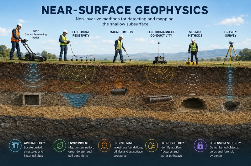
What Is Near-Surface Geophysics?
Near-surface geophysics focuses on the investigation of the shallow part of the Earth where geological, environmental, engineering, and human-made features can be investigated using measurements made at or close to the ground surface.
There is no single depth that defines the boundary of near-surface geophysics. The appropriate investigation depth depends on the method, the physical properties of the ground, the equipment being used, and the objective of the survey. Some investigations target only the upper few meters, while other techniques can investigate considerably deeper sections of the subsurface.
The main principle is that different underground materials and structures have different physical properties. A buried metal object, a void, a water-saturated zone, a rock layer, a buried wall, or a geological contact can produce a measurable contrast relative to the surrounding material.
By measuring these contrasts across an area, a geophysicist can create a map or profile showing variations in the subsurface.
How Does a Near-Surface Geophysical Survey Work?
A typical survey consists of several stages:
- Survey design – selecting an appropriate geophysical method based on the target, expected depth, ground conditions, and required resolution.
- Data acquisition – collecting measurements along survey lines, grids, or other predefined geometries.
- Data quality control and reduction – correcting or removing unwanted variations and measurement errors.
- Data processing – improving the signal-to-noise ratio and preparing the data for interpretation.
- Modeling and inversion – converting measured physical responses into estimates of subsurface properties where appropriate.
- Interpretation – relating geophysical anomalies to possible geological, archaeological, environmental, or man-made features.
Geophysical measurements can be collected along individual profiles, across two-dimensional survey grids, or using dense arrays to produce three-dimensional models. Surveys can also be repeated over time to monitor changes in subsurface conditions.
Major Near-Surface Geophysical Methods
Near-surface geophysics includes several different groups of techniques. Each method responds to a different physical property, so the best method depends strongly on the target and the surrounding ground.
Ground Penetrating Radar (GPR)
Ground Penetrating Radar, or GPR, uses electromagnetic waves to investigate changes in the subsurface. Reflections can occur where there is a contrast in electromagnetic properties between different materials.
GPR is particularly useful for relatively shallow investigations where the ground conditions allow sufficient radar penetration. It can be used to locate buried utilities, pipes, foundations, voids, archaeological structures, pavement layers, graves, and other subsurface features.
The achievable depth and resolution depend strongly on antenna frequency, soil and rock properties, moisture content, electrical conductivity, target size, and other site conditions. Therefore, a specific maximum depth cannot be assigned to GPR for every environment.
GPR is one of the most widely used near-surface geophysical techniques in archaeology, engineering, forensic investigations, hydrogeology, and infrastructure surveys.
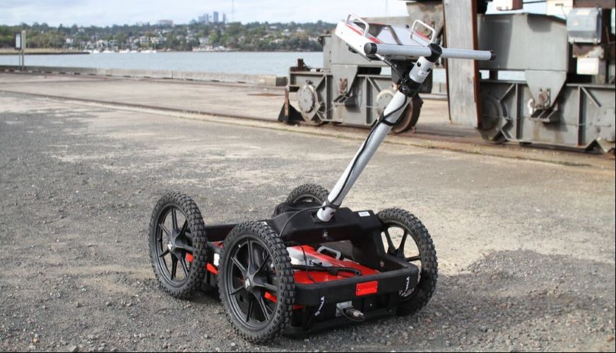
MALA Easy Locator Pro WideRange HDR
Electrical Resistivity
Electrical resistivity methods measure how strongly the ground resists the flow of electrical current. Different soils, rocks, water conditions, and buried structures can have substantially different electrical resistivities.
Electrical resistivity surveys commonly use electrodes inserted into the ground. By changing the electrode configuration and measurement locations, information about variations in resistivity with depth and across an area can be obtained.
Electrical Resistivity Tomography (ERT) is particularly useful when a two-dimensional or three-dimensional representation of subsurface resistivity is required.
Applications include groundwater investigations, geological mapping, archaeology, environmental studies, void detection, and geotechnical investigations. Typical investigation depth depends on electrode spacing, array configuration, ground conditions, and survey design.

ABEM Terrameter VES and VES MAX
Magnetic Surveying
Magnetic surveying measures variations in the Earth's magnetic field caused by differences in the magnetic properties of subsurface materials.
Magnetometers can detect magnetic anomalies associated with ferrous objects, archaeological features, burned structures, geological bodies, buried pipes, mine workings, and other targets.
Magnetic surveys are particularly useful when the target produces a measurable magnetic contrast with the surrounding ground. Because the method does not require physical contact with the ground, large areas can often be surveyed relatively quickly.
Magnetometry is widely used in archaeology, geological mapping, mineral exploration, environmental investigations, and the detection of certain buried structures and metallic objects.
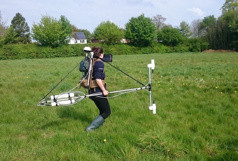
G-864 Caesium Magnetometer Vertical Gradiometer
Electromagnetic Conductivity Methods
Electromagnetic (EM) conductivity methods measure the electromagnetic response of the ground to estimate variations in electrical conductivity or related properties.
These systems generally use transmitter and receiver coils or other electromagnetic sensors. Depending on the system, measurements can be made from the ground, water, or air.
EM conductivity surveys can be useful for rapid reconnaissance and mapping changes in soil properties, groundwater conditions, contamination, archaeological features, and other subsurface variations.
They can cover relatively large areas efficiently, although electromagnetic interference from power lines, buildings, vehicles, and other sources can affect measurements in some environments.
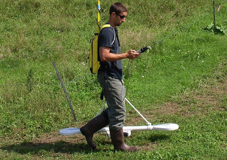
GSSI Profiler EMP-400
Seismic Methods
Seismic methods use mechanical waves that travel through the ground. Changes in seismic velocity and wave behavior can provide information about subsurface layers and material properties.
Two important near-surface seismic techniques are seismic refraction and seismic reflection.
Seismic refraction analyzes the travel paths and arrival times of seismic waves to estimate subsurface velocities and identify changes between geological layers.
Seismic reflection analyzes waves reflected from subsurface boundaries. It can provide detailed information about geological structures and layer boundaries.
Seismic methods are commonly used in engineering, geotechnical investigations, geological studies, groundwater research, and other subsurface investigations.

Gravity and Microgravity Surveys
Gravity methods measure small variations in the Earth's gravitational field caused by differences in subsurface density.
In near-surface investigations, high-precision microgravity measurements can be used to identify density anomalies. Features such as cavities, sinkholes, old mine workings, and other structures with a density contrast may produce measurable anomalies.
Because gravity anomalies are generally broad and can be influenced by multiple sources, interpretation usually requires careful survey design and modeling.
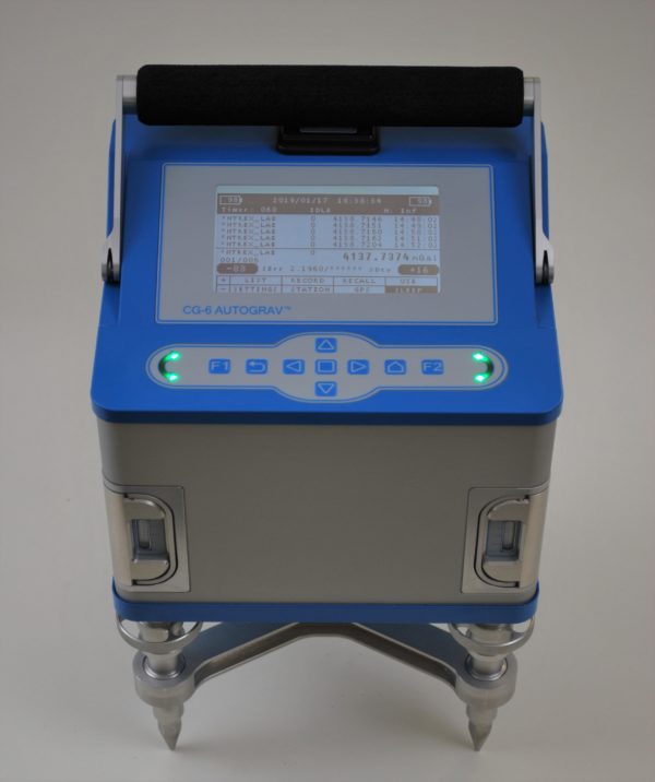
Scintrex CG-6 Autograv Gravity Meter
Induced Polarization and Other Electrical Methods
Induced Polarization (IP) measures the delayed electrical response of subsurface materials after an electrical current is applied. It is particularly useful for investigating materials and geological environments that exhibit polarization effects.
Other electrical techniques include Self-Potential (SP) and complex resistivity methods. These techniques are used in different geological, environmental, hydrogeological, and mineral exploration applications.
The U.S. Environmental Protection Agency groups electrical resistivity, induced polarization, complex resistivity, and self-potential among the major electrical methods used for shallow subsurface investigations.
Comparing Near-Surface Geophysical Methods
No single geophysical method is ideal for every subsurface target. Each technique responds to a different physical property and has its own advantages and limitations.
| Method | Main physical property | Typical strengths | Common applications |
|---|---|---|---|
| GPR | Electromagnetic / dielectric properties | High-resolution shallow imaging | Utilities, archaeology, voids, structures |
| Electrical Resistivity / ERT | Electrical resistivity | Mapping resistivity variations with depth | Groundwater, voids, geology, archaeology |
| Magnetometry | Magnetic field | Rapid detection of magnetic anomalies | Archaeology, ferrous objects, geology |
| EM Conductivity | Electrical conductivity / EM response | Rapid area reconnaissance | Soil, contamination, archaeology |
| Seismic Refraction | Seismic velocity | Layer and velocity estimation | Geotechnical, geology, engineering |
| Seismic Reflection | Acoustic impedance contrasts | Imaging subsurface boundaries | Geological and engineering investigations |
| Microgravity | Density variations | Detection of density anomalies | Cavities, sinkholes, mine workings |
| Induced Polarization | Electrical polarization | Characterizing polarized materials | Mineral and environmental investigations |
The table should be viewed as a general comparison rather than a fixed specification. Actual performance depends on the equipment, survey configuration, target characteristics, geology, soil conditions, environmental noise, and data-processing workflow.
Near-Surface Geophysics for Void Detection
One of the important applications of near-surface geophysics is the investigation of underground cavities and voids.
A void may produce a contrast in one or more physical properties relative to the surrounding material. Depending on the size, depth, geometry, and geological setting of the cavity, different geophysical techniques may be appropriate.
GPR can sometimes identify reflections associated with the boundaries of shallow cavities. Electrical resistivity can reveal resistivity contrasts associated with air-filled or water-filled spaces. Microgravity can detect density deficits caused by underground cavities, while seismic methods can identify changes in the mechanical properties of the subsurface.
For difficult targets, using more than one geophysical method can provide stronger evidence than relying on a single measurement.
Near-Surface Geophysics in Archaeology
Geophysical surveying has become an important tool in archaeological investigations because it can reveal subsurface features without extensive excavation.
Walls, foundations, ditches, pits, hearths, kilns, graves, and other archaeological features can produce contrasts in magnetic, electrical, electromagnetic, or radar properties.
Magnetometry is particularly useful for features that produce magnetic anomalies, while electrical resistivity and GPR can provide complementary information about buried structures and changes in subsurface materials.
The main advantage is that large areas can be investigated non-destructively before excavation, allowing archaeologists to identify promising targets and plan excavations more efficiently.
Engineering and Geotechnical Applications
Near-surface geophysics is widely used in engineering and construction projects to investigate ground conditions before or during development.
Applications include:
- Mapping geological layers
- Locating buried utilities
- Investigating foundations
- Identifying voids and subsurface cavities
- Mapping fractures and geological discontinuities
- Assessing pavement and concrete structures
- Investigating landslide-related features
- Supporting groundwater studies
- Detecting abandoned structures and buried infrastructure
Geophysical methods can provide information between boreholes or across areas where conventional drilling alone would provide limited spatial coverage.
Environmental and Hydrogeological Applications
Near-surface geophysics can also be used to investigate groundwater, contamination, soil properties, and interactions between surface water and the subsurface.
Electrical and electromagnetic methods are particularly useful for mapping changes in electrical conductivity and resistivity, which can be influenced by moisture, dissolved minerals, salinity, clay content, and contamination.
Geophysical surveys can therefore provide spatial information that complements direct sampling and borehole investigations. Environmental geophysics encompasses applications ranging from groundwater and watershed studies to contamination assessment and remediation.
Forensic and Subsurface Investigations
Near-surface geophysical methods can be used in forensic investigations to search for buried objects, disturbed ground, graves, and other subsurface anomalies.
GPR, magnetometry, electrical resistivity, and electromagnetic methods can be selected according to the expected target and ground conditions.
In forensic applications, the objective is often not simply to produce an image of the subsurface, but to identify anomalies that justify further investigation while minimizing unnecessary excavation.
2D and 3D Geophysical Surveys
Near-surface surveys can be designed to produce different levels of spatial information.
A single survey line can produce a two-dimensional profile showing changes along the survey direction and with depth.
A grid consisting of multiple parallel survey lines can be used to create maps of anomalies across an area. With suitable data coverage and processing, multiple measurements can also be combined to produce three-dimensional models of subsurface properties.
Three-dimensional surveying generally requires greater data density and more extensive processing than a single profile, but it can provide a more complete representation of complex subsurface structures.
Why Use More Than One Geophysical Method?
Different geophysical methods respond to different physical properties. As a result, the same underground target can appear very differently in different datasets.
For example, a buried metallic object may produce a strong magnetic anomaly but a weak GPR response. A water-bearing zone may produce a strong electrical resistivity contrast while producing a less distinctive magnetic response.
Combining methods can therefore reduce ambiguity and improve confidence in interpretation.
A common approach is to use a rapid reconnaissance method to identify anomalies and then apply a higher-resolution or complementary method to investigate selected areas in greater detail.
Limitations of Near-Surface Geophysics
Geophysical surveying does not provide a direct photograph of the subsurface. Measurements are indirect observations of physical properties, and the resulting anomalies must be interpreted.
Several factors can affect the quality of a survey:
- Soil and rock properties
- Ground moisture
- Electrical conductivity
- Target size and depth
- Target orientation
- Surface conditions
- Cultural and electromagnetic noise
- Survey geometry
- Instrument frequency and sensitivity
- Data-processing parameters
- Insufficient survey coverage
Another important limitation is that different underground structures can sometimes produce similar geophysical responses. Consequently, a geophysical anomaly does not automatically identify a specific object.
Reliable interpretation usually requires knowledge of the geology, site conditions, survey design, and physical principles of the selected method.
Near-Surface Geophysics vs. Direct Investigation
The main advantage of geophysical methods is that they can investigate large areas without requiring continuous excavation or drilling.
However, geophysical surveying and direct investigation are complementary rather than competing approaches.
A geophysical survey can identify anomalies and provide a map of subsurface variations. Drilling, excavation, coring, or other direct methods can then be used to verify the nature of selected targets.
For this reason, an effective investigation often combines geophysical measurements with geological information and targeted direct observations.
Choosing the Right Geophysical Method
Selecting a geophysical method should begin with the target rather than the instrument.
Important questions include:
- What is the target?
- What is its approximate size?
- How deep is it expected to be?
- Is it metallic, non-metallic, geological, or an empty space?
- What are the soil and rock conditions?
- Is the target expected to produce a magnetic, electrical, electromagnetic, density, or seismic contrast?
- Is the priority detection, mapping, depth estimation, or detailed imaging?
- What level of spatial resolution is required?
For example, GPR may be appropriate when high-resolution shallow imaging is required and the ground has favorable electromagnetic properties. Electrical resistivity may be more suitable when resistivity contrasts are expected or greater investigation depth is required. Magnetometry can be highly effective for magnetic targets, while seismic or gravity methods may be preferable for certain geological or cavity investigations.
In complex projects, combining two or more methods can provide a more reliable interpretation than relying on a single technique.
Conclusion
Near-surface geophysics provides a non-destructive way to investigate and map the shallow subsurface using measurable physical properties. GPR, electrical resistivity, magnetometry, electromagnetic conductivity, seismic methods, gravity, and induced polarization each provide a different view of underground conditions.
The most appropriate technique depends on the target, depth, geology, ground conditions, required resolution, and survey objective. In many investigations, the best results are obtained by combining complementary geophysical methods and integrating their results with geological and site information.
For archaeology, engineering, environmental studies, hydrogeology, forensic investigations, infrastructure surveys, and other subsurface applications, near-surface geophysics can significantly reduce the need for indiscriminate excavation and provide valuable information about what lies beneath the ground before direct investigation begins.


