Loza-V Pulsed Electromagnetic Geophysical System
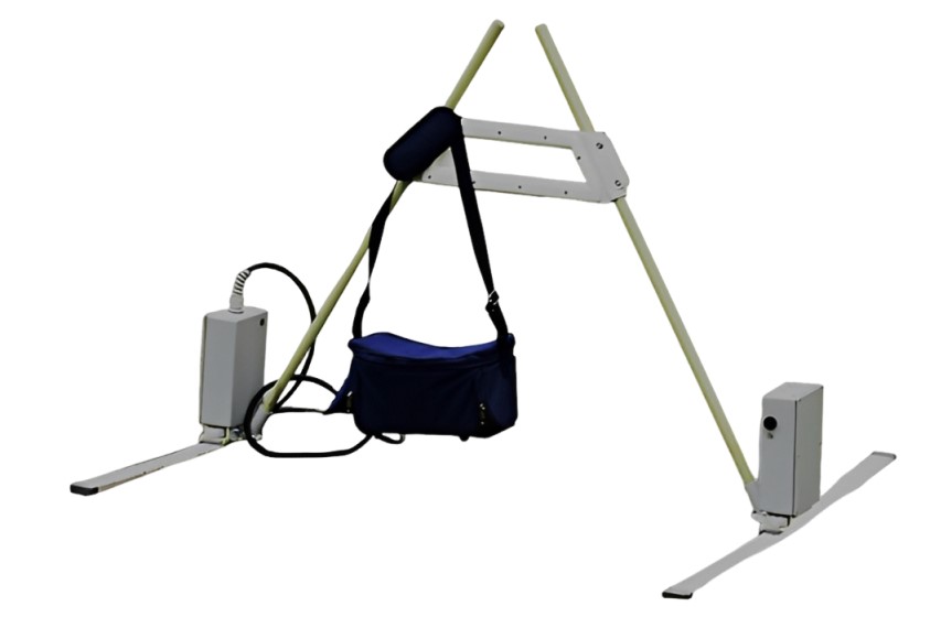
The Loza-V is a mid-frequency pulsed electromagnetic geophysical system developed for subsurface investigation in challenging geological conditions. It is designed for engineering geology, near-surface hydrogeology, archaeology, infrastructure surveys, and general subsurface mapping.
Developed by GPR Investigation, the Loza-V uses pulsed electromagnetic signals and configurable antenna systems to investigate subsurface structures and variations in electromagnetic properties. Its frequency and acquisition configuration can be selected according to the target, ground conditions, and required balance between investigation depth and resolution.
With frequency configurations ranging from 50 to 400 MHz, the Loza-V covers a wide range of near-surface and moderate-depth investigation requirements. The system is particularly intended for applications where conventional high-frequency GPR systems may experience reduced penetration in clay-rich, mineralized, or otherwise challenging ground conditions.
Actual investigation depth depends on soil conductivity, moisture, geological conditions, target characteristics, antenna configuration, survey geometry, and acquisition parameters.
Key Features
-
Mid-frequency pulsed electromagnetic geophysical system
-
Frequency range of 50–400 MHz depending on antenna configuration
-
Configurable antenna systems
-
Multiple acquisition time windows
-
256, 512, 1024, and 2048 ns registration windows
-
Pulse repetition rate of up to 1000 Hz, depending on operating mode
-
Designed for shallow to moderate-depth subsurface investigation
-
Suitable for challenging and heterogeneous ground conditions
-
High-energy pulsed transmission compared with conventional high-frequency GPR systems of similar portability
-
Suitable for engineering geology and geotechnical surveys
-
Near-surface hydrogeological investigation
-
Archaeological geophysics
-
Infrastructure and subsurface mapping
-
Field operation in temperatures from approximately -20 °C to +50 °C
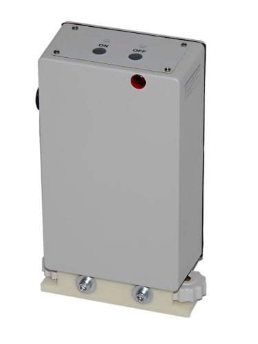
Loza-V Transmitter
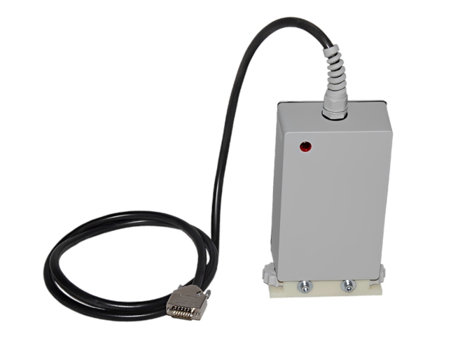
Loza-V Receiver
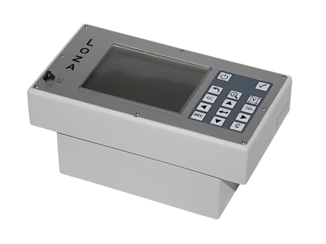
Loza-V Control Unit
Loza-V Electromagnetic Technology
The Loza-V belongs to a family of pulsed electromagnetic systems developed for subsurface investigation using short electromagnetic pulses.
During a survey, electromagnetic energy is transmitted into the ground and the returning response is recorded over a defined time interval. The recorded signal can contain information related to subsurface boundaries, changes in electromagnetic properties, and conductive or resistive structures.
The relationship between frequency, pulse characteristics, recording time, antenna configuration, and ground conductivity determines the practical investigation range and resolution.
The Loza approach also considers both early-time electromagnetic responses and later-time responses. This allows the acquired data to contain information related to subsurface structure as well as electromagnetic conductivity behavior.
Frequency Range and Configurable Antennas
One of the important characteristics of the Loza-V is its configurable antenna system.
The system supports frequency configurations from approximately 50 to 400 MHz. Different frequencies provide different compromises between resolution, penetration, and sensitivity to geological conditions.
Higher-frequency configurations can provide greater sensitivity to smaller and shallower features, while lower-frequency configurations can be used when greater penetration is required.
The appropriate antenna configuration should therefore be selected according to the geological environment and the objective of the survey.
Performance in Challenging Ground
Ground conductivity is one of the most important factors affecting electromagnetic and GPR investigation depth.
Clay-rich soils, heavy clay, mineralized ground, saline environments, and wet soils can significantly attenuate electromagnetic signals. In such conditions, conventional high-frequency GPR systems can experience substantial reductions in penetration.
The Loza-V is designed with a pulsed, relatively high-energy approach intended to maintain usable signal levels in more challenging ground conditions.
This makes the system particularly relevant for geological and archaeological environments where soil properties can limit the performance of conventional GPR equipment.
However, no electromagnetic system provides a fixed investigation depth in all geological environments. Actual results depend on the specific site and survey configuration.
Investigation Depth
The practical investigation depth of Loza-V varies considerably according to ground conditions and the selected antenna configuration.
Published field information for Loza-V includes successful investigations at depths of approximately 14–20 m under specific test conditions. GPR Investigation also reports typical archaeological investigations in the range of approximately 3–8 m, while other configurations and favorable geological conditions may provide greater investigation depths.
For this reason, a fixed maximum depth should not be assumed for every site.
Factors affecting achievable depth include:
-
Soil electrical conductivity
-
Clay content
-
Ground moisture
-
Mineralization
-
Geological stratigraphy
-
Target size and contrast
-
Antenna frequency
-
Antenna configuration
-
Survey geometry
-
Transmitter and receiver configuration
-
Signal attenuation
A site-specific survey assessment is recommended when a particular investigation depth is required.
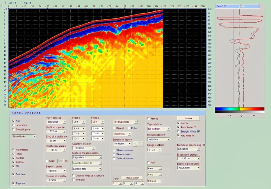
Krot Software
Applications
Archaeological Surveys
Loza-V can be used for non-invasive archaeological investigations and mapping of buried structures and cultural layers.
Potential targets include:
-
Buried walls and foundations
-
Archaeological structures
-
Pits and disturbed ground
-
Stratigraphic boundaries
-
Buried surfaces
-
Voids and cavities
-
Historical settlement features
-
Other subsurface anomalies
The system has been used in archaeological environments containing clay-rich and heavy chernozem soils, where electromagnetic signal attenuation can be a significant challenge.
Engineering Geology
The Loza-V can support engineering and geotechnical investigations by providing information about subsurface structures and anomalies.
Potential applications include:
-
Subsurface structural mapping
-
Geological boundary investigation
-
Void and cavity surveys
-
Infrastructure investigations
-
Ground condition assessment
-
Identification of disturbed zones
-
Investigation of subsurface discontinuities
Near-Surface Hydrogeology
Electromagnetic measurements can provide information about geological structures and electromagnetic property variations associated with groundwater-bearing formations.
Potential applications include:
-
Near-surface groundwater investigation
-
Aquifer-related structural mapping
-
Fracture and fault investigation
-
Buried channel mapping
-
Hydrogeological profiling
Interpretation of groundwater-related anomalies should be performed together with geological and hydrogeological information whenever possible.
Infrastructure Surveys
Loza-V can be applied to subsurface investigations associated with roads, construction areas, infrastructure corridors, and other engineering projects.
The system can help identify subsurface boundaries, disturbed zones, voids, and other anomalies relevant to engineering assessment.
Archaeological Geophysics
Loza-V has particular relevance to archaeological surveys because many archaeological sites are located in soils that can be challenging for conventional GPR.
GPR Investigation reports the use of Loza-V in archaeological projects involving clay-rich soils and heavy chernozem. Survey data can be processed to produce subsurface sections and plan-view interpretations that help identify areas requiring further archaeological investigation.
A major advantage of non-invasive geophysical surveying is the ability to investigate an archaeological site before excavation, allowing researchers to prioritize potential targets while minimizing unnecessary ground disturbance.
Data Acquisition
The Loza-V supports multiple registration time windows:
-
256 ns
-
512 ns
-
1024 ns
-
2048 ns
The selected recording window determines how long the electromagnetic response is observed after each transmitted pulse.
Shorter windows can be appropriate for shallower, higher-resolution investigations, while longer windows allow the system to record later electromagnetic responses when deeper investigation is required.
The maximum useful recording time is not equivalent to a guaranteed physical investigation depth. Ground attenuation and signal-to-noise conditions determine how much useful information remains at later times.
Pulse Repetition Rate
The Loza-V supports pulse repetition rates of up to approximately 1000 Hz, depending on the operating mode.
A high pulse repetition rate can support efficient data acquisition and dense spatial sampling during field surveys. The actual acquisition rate depends on the selected configuration, survey geometry, terrain, and operational conditions.
Field Operation
The Loza-V is designed for field deployment in a wide range of environmental conditions.
The published operating temperature range is approximately -20 °C to +50 °C.
The system can be deployed in archaeological, geological, engineering, and hydrogeological environments where portability and field flexibility are important.
Advantages of Loza-V
-
Configurable frequency range for different investigation requirements
-
Multiple recording windows for shallow and deeper targets
-
Pulsed electromagnetic operation
-
Designed for challenging ground conditions
-
Suitable for archaeological and engineering investigations
-
Supports near-surface hydrogeological surveys
-
High data acquisition rate
-
Field-oriented system design
-
Suitable for non-invasive subsurface investigation
-
Can provide structural and electromagnetic property information from the same survey dataset
Loza-V vs. Conventional High-Frequency GPR
Conventional high-frequency GPR systems can provide excellent resolution for shallow targets, but their penetration can be significantly reduced in conductive soils such as clay-rich or wet ground.
Loza-V uses a different pulsed electromagnetic configuration and a wider range of operating frequencies. This makes it suitable for applications where a compromise between resolution and penetration is required.
The choice between Loza-V and a conventional GPR system should always be based on the target, expected depth, geological conditions, required resolution, and survey objectives.
Non-Invasive Subsurface Investigation
Loza-V can be used for non-destructive and non-invasive geophysical surveys. Instead of excavating or drilling across an entire area, electromagnetic measurements can first be used to identify subsurface anomalies and areas of interest.
This approach can be particularly valuable in archaeological sites, protected areas, construction zones, and locations where unnecessary excavation or ground disturbance should be minimized.
Important Note About Detection Depth
There is no single guaranteed maximum depth for Loza-V.
Electromagnetic investigation depth varies with geological and environmental conditions. Published results from different Loza-V applications show different effective depths, reflecting differences in soil conductivity, antenna configuration, target properties, and survey methodology.
For professional projects, the expected investigation depth should therefore be evaluated according to the specific site rather than relying on a single nominal depth specification.
Applications Summary
Loza-V is suitable for:
-
Archaeological geophysical surveys
-
Engineering geology
-
Geotechnical investigations
-
Near-surface hydrogeology
-
Subsurface mapping
-
Infrastructure surveys
-
Geological structure mapping
-
Void and cavity investigation
-
Buried feature detection
-
Cultural-layer mapping
-
Environmental and site investigations
Technical Specifications
| Specification | Details |
|---|---|
| Model | Loza-V |
| System Type | Mid-Frequency Pulsed Electromagnetic Geophysical System |
| Frequency Range | 50–400 MHz |
| Frequency Configuration | Antenna-dependent |
| Time Resolution | 1 / 2 / 4 ns |
| Registration Time Window | 256 / 512 / 1024 / 2048 ns |
| Pulse Repetition Rate | Up to 1000 Hz, mode-dependent |
| Operating Temperature | Approximately -20 °C to +50 °C |
| Antenna Configuration | Multiple configurations available |
| Primary Applications | Engineering geology, hydrogeology, archaeology, infrastructure, subsurface mapping |
| Investigation Depth | Site- and configuration-dependent |
| Manufacturer / Developer | GPR Investigation |
| Product Family | Loza Electromagnetic Systems |